Paper
delivered in conjunction with the National Gallery of Australia's
exhibition: Revealing the Holy Land
A
paper to examine the nineteenth century photographers
and the photographs of the Holy Land. In order to examine these,
it is important to first study the contemporary social and
political context that made the Near East the focus for nineteenth
century
Europeans of all social classes, but especially for the newly emerging
middle class of England.
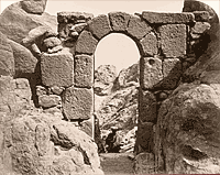 |
Sergeant
James McDonald, Archway on the Ascent to Jebel Músá at
Which Pilgrims Were Formerly Confessed, 1868-1869. |
Until the beginning of the nineteenth century, travel to foreign lands had been confined largely to the aristocracy, the church, the military and a small merchant class. However the social and economic ferment that accompanied the Industrial Revolution in Europe and England rapidly changed that situation. Several factors appear to have combined to produce an explosion of public interest in the Near East in both France and England from about the middle of the eighteenth century.
Both France and England had strong military interests in Egypt, not least because of its strategic location with respect to the eastern Mediterranean and the Indian Ocean. Those interests sharpened with Napoleon’s invasion of Egypt in 1798. England allied itself with the Ottoman Empire against the French, providing naval forces to bombard Napoleon’s operations at the final land battle, the siege of Acre in 1799, and then defeating the French naval forces at Aboukir Bay.
English fascination with the Near East was, however, far deeper than just a response to a passing military problem. From the reign of Henry VIII, strengthened by the puritan interlude of Cromwell, the English had had a strong link with what was then referred to as Palestine, a link founded in religion but extending far beyond that boundary. Thomas Huxley, who gave the language the term “agnostic” speaks of the relationship of English history and the Bible in the following terms “consider the great historical fact that this book has been woven into the life of all that is best and noblest in British history, that it has become the national epic of Britain”. The Archbishop of York, William Thompson referring to Palestine in 1865, said “This country of Palestine belong to you and me, it is essentially ours. It is the land towards which we may look with as a true a patriotism as we do this dear old England which we love so much”.
By the early part of the nineteenth century there was a growing belief in the Millennium and the imminent Second Coming of Christ, a precondition of which was the return of the Jews to their homeland and their conversion to Christianity. This saw the rapid rise of a great diversity of missionary societies in both Britain and the United States. In the early 1830's, the London Society for the Promotion of Christianity amongst the Jews sent the Rev Nicolayson to Jerusalem. Lutheran Prussia and the Anglican church combined to appoint the first Protestant bishop to Jerusalem, Solomon Alexander, a converted Jew. Competition among European nations to sponsor and protect their chosen religions in Palestine soon had a dramatic impact not only on the inhabitants of the region, especially Jerusalem, but on the actual infrastructure of the city itself. France supported the Catholics, Russia the Orthodox, Britain/Prussia the Protestant faiths, while the Rothschild family and the great English philanthropist, Sir Moses Montefiori sought to ameliorate the position of the Jews building hospitals and schools.
Artists, theologians, historians, pilgrims and travellers journeyed to the East in rapidly increasing numbers. By the early 1840's, travellers such as W.H. Bartlett and A.H. Stanley, the Dean of Westminster, had published popular accounts of their travels to Sinai, Palestine and Jerusalem, illustrated with steel engravings. Similarly, Alexander Kingslake’s Eöthen, published in 1844, an account of his overland journey from Greece to Egypt undertaken nine years earlier, and Thackery’s Notes of a Journey from Cornhill to Grand Cairo, published in 1845 under the pseudonym of Titmarsh, were among the most popular books of their day. The most complete visual record of the region at this time was the six volume collection of coloured lithographs from drawings made in the 1830's by the Scottish painter David Roberts. Published originally between 1842 and 1849, these were so popular that they were re-issued in 1855-56 under the title The Holy Land, Syria, Idumea, Arabia, Egypt & Nubia from Drawings made on the spot by David Roberts.
While these publications served to whet the appetites of archaeologists and Biblical scholars alike, there were no accurate scientific accounts of the region. Burton and Speke were not to set out on their epic journey to discover the source of the Nile until 1858, two years after Frith made his first journey. France appointed a Director of the Antiquities Service in Egypt in 1850 but in the rest of the region no systematic work was undertaken until the 1860's.
Popular knowledge of the pre-Christian history of the whole region was tied, at least in England, to the accounts presented in the Bible while the reconciliation of the accounts of the Mosaic tradition with the actual geography of Egypt, Sinai and Palestine was one of the most pressing and difficult problems of sacred geography. Which of the several likely mountains in Sinai was in fact the mountain referred to in the narrative of the Giving of the Law?
The first serious, planned expedition to photograph the historic places and monuments of the region was undertaken by the Englishman, Francis Frith. Frith was born in Chesterfield in 1822 to a Quaker family. After leaving school at 16 Frith was subsequently apprenticed to a Sheffield cutler but at 21 he suffered a serious mental and physical breakdown. During his lengthy convalescence, Frith experienced a religious conversion, his faith becoming the central focus of his life from this point. By his early 30's he had made a small fortune in the importing business and retired to follow his interest in photography. In 1853 he became one of the founders of the Liverpool Photographic Society, one of the main centres for photography in England at this time.
According to at least one historical source, Frith was one of the most technically advanced photographers in the country by the time of his first voyage to Egypt in 1856. Frith was a man of strong religious belief who determined to experience, first hand, the locations mentioned in the Bible - Egypt, Sinai and Palestine. At the same time his business acumen, already well demonstrated by his financial independence at the early age of 34, recognised that his photographs of such places would find a ready commercial acceptance among a like-minded Victorian public. The unquestioned veracity of the evidence of the photograph far outweighed the testament of the written account or the artistic interpretation of the modern traveller in such questions.
Frith’s first published work from this first voyage, a series of glass stereo photographs, were shown at meetings of the Photographic Society in the spring of 1857 but not published for fear of commercial piracy until very late that year. They attracted wide public acclaim in The Times, and The Athenaeum and in the photographic press of the day not only for their photographic quality but also for their contribution to historical and educational uses.
Frith returned from Egypt in July 1857 only to set out in November of that year for Syria and Palestine, visiting Jerusalem, Baalbec, Damascus and the great cedars of Lebanon before returning in May of 1858. His third and final journey to the Near East was undertaken in the summer of 1859. Frith travelled some 1500 miles up the Nile to the region of the Sixth Cataract, the first photographer to penetrate so far south, although the most southerly of his photographs are from Soleb, which is down-river from the Third Cataract. Returning to Cairo, Frith went by camel across the Sinai by the ‘long route’ to Gaza, Jerusalem, through Palestine and thence to London via Jaffa, the Bosphorus, Constantinople and the Greek islands.
Frith was dedicated to his aim of conveying an accurate, truthful expression of what he himself had seen and, to this end, Frith made extensive use of the latest architectural and archaeological scholarship in researching his journeys and in checking the accuracy of the captions that he wrote to accompany each plate.
Frith made a considerable contribution to the publication of photographic images. His own experiments convinced him that there was as yet no satisfactory photomechanical substitute for the actual photographic print. His Reigate firm of F. Frith & Co, which continued under family control until 1968, operated to the highest standards of modern printing practice, using very carefully prepared copy negatives and the most sophisticated methods of masking and retouching
Egypt and Palestine Photographed and Described, the first of Frith’s planned publications contained 76 photographs, appearing in 25 parts available on subscription between January 1858 and the spring of 1860 in separate English and American editions. The price in England was ten shillings per issue, a substantial sum for the period. The photographs are taken from the material accumulated from the first two trips made by Frith over the period 1856-58. Of particular note is the comment by van Haaften (Egypt and the Holy Land in Historic Photographs, 77 Views by Francis Frith, Dover Publications, Inc., New York, 1980), that of the 274 subscribers to the English edition about 1 in 15 were members of the clergy.
Frith’s output of photographically illustrated volumes was such that by 1862 The Photographic Journal reported “ The extent of Mr Frith’s publications is becoming almost alarming”.
The Gallery’s volume Sinai and Palestine published in 1862 was part of a four-volume re-issue of earlier publications. The series was initially available by subscription, and is uniform with the earlier publications except that the 148 albumen prints are arranged by region, thus Sinai and Palestine; Lower Egypt, Thebes, and the Pyramids; Upper Egypt and Ethiopia; and Egypt, Sinai and Palestine. Supplementary Volume. The texts, apart from those on Ethiopia, are mostly reprints of those appearing with the original or similar views.
The second of the items to be examined, The Ordnance Survey of the Sinai Peninsula, has a more curious background. While it was carried out by members of the Royal Engineers, all of its expenses, including the salaries of the military staff, were met by public subscription. Indeed, the Director General of the Ordnance Survey, Major General Sir Henry James, actively solicited subscriptions for its support. The military staff were selected by James and granted permission to participate by the Secretary of State for War. Yet the all of the results of the survey clearly remained the property of the British Government as shown by the permission to publish granted by the Secretary of State for War. Given the fact that the Indian Navy had earlier surveyed the whole of the coast of Sinai, there can be little doubt that the Government had an eye to the possible future military use of the information. Certainly the very careful surveys of Palestine taken by another member of the Royal Engineers while a member of the Palestine Exploration Fund were used by General Allenby in planning his Palestine campaign in 1917.
Certainly the Royal Engineers of that time were the pre-eminent experts in large-scale survey. The then Captain Wilson who would command the Survey in Sinai had already established his reputation in large-scale surveys. He had served as secretary to the expedition of 1858 to survey the boundary between America and Canada, the North American Boundary Commission; been appointed commander of the Ordnance Survey of Scotland; commanded the privately funded Ordnance Survey of Jerusalem, established for the purpose of endeavouring to improve the sanitary state of the city, and, following the Parliamentary reform Act of 1867, was appointed as Assistant Commissioner to enquire into the existing boundaries of the parliamentary constituencies of the West Midlands District of England. When the notion of a survey of the Sinai was announced, Wilson wrote to Sir Henry advising that he was prepared to go out for nothing and undertaking to raise £200 from among his friends.
The central purpose of the Survey is conveyed in the words of the Reverend Williams in the introduction “That there is a great need to carry out such a survey must be manifest to all students of Old Testament history; among the most important and interesting questions which are now subjects of inquiry are the locations of the Passage of the Red Sea, the Route and Encampments of the Israelites, and the identification of the Mountain of the Law Giving.”
Sir Henry’s instructions to Captain Wilson noted “all the existing maps of the peninsula of Sinai are said to be extremely defective, and the object of the Ordnance Survey is to produce an accurate map of so much of the peninsula as can be made in the time allowed for it....This map is especially required by Biblical scholars and the public, to illustrate the Bible history, and to enable them, if possible, to trace the routes which were taken by the Israelites in their wanderings in the wilderness of Sinai and to identify the mountain from which the Law was given.” They were also instructed to examine the monastic and other remains of antiquity in the peninsula, collect information on water supply, meteorology, geology and natural history with particular reference to the native nomenclatures, Arab traditions, Sinaitic inscriptions and Egyptian monuments in the country.
Included in the party was Colour-Sergeant James McDonald, chosen for his expertise both as surveyor and photographer. The Royal Engineers, and their predecessor Corps, the Royal Sappers and Miners, were probably the first public body to institute formal training in photography as a part of normal training. Just as Allegro in France had advanced the potential of photography as a mechanism for accurately recording Egyptian hieroglyphs, Alexander Gordon had lectured the Institute of Civil Engineers in England in 1840 on its uses for civil engineering. The Royal Engineers Establishment at Chatham, founded in 1812 rapidly expanded its brief military curriculum to include practical architecture in 1826 and surveying in 1833. Astronomy and submarine mining followed with the Corps being involved in a great range of civil construction projects, including the building and early running of the South Kensington Museum, the Great Exhibition of 1851 and the Paris Exhibition of 1855. The earliest known use of photography by the Corps was the despatch of two members of the Sappers and Miners to the Crimean War in 1854. Sadly both were drowned in Balaclava Harbour and their equipment lost.
MacDonald had been a member of the earlier survey of Jerusalem, again funded by private subscription but with the Engineers providing the leadership and technical staff. On this occasion MacDonald was chosen for his skill as a surveyor but had the added task of taking photographs of significant holy places in the city when not engaged in surveying. This latter task was a personal charge placed on him by Sir Henry James who provided the necessary photographic equipment at his own expense.
The resulting images contained in the published accounts of these two Surveys are among the finest examples of nineteenth century topographical landscape photography. Far from being just simple records, MacDonald’s photographs show a careful attention to the selection of viewpoint, the use of light and shade and often subtle placing of figures to provide the eye with some reference for scale and distance.
Nineteenth century expeditionary photography played a major role in popularising the medium and in the development of a general belief that travel was increasingly within the means of the ordinary person. But its most important contribution was in broadening the social and cultural horizons of nineteenth century Western civilisation, of taking its citizens out of the familiar comfort of their own surroundings by exposing them to cultures, customs and people whose civilisations were often far older.
The National Gallery is fortunate to have two pristine examples of this important phase in the evolution of photography.
© Robert Deane 2000